Quote of the Month:
“Nature gives to every time and season some beauties of its own." - Charles Dickens
“Nature gives to every time and season some beauties of its own." - Charles Dickens
| Location: | Northwestern coast of the Olympic Peninsula |
| Roundtrip: | 9,2 miles |
| Difficulty: | Easy |
| Elevation Gain: | 100 feet |
| Highest Point: | 350 feet |
| GPS Coordinates: | N 48 9.219 W -125 19.882 |
| Visitor’s Information: |
Discover Pass Required |
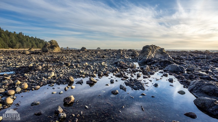
The Olympic Peninsula is one of the most interesting and diverse parts of Washington State. Millions of tourists visit it throughout the year, attracted by a wide range of attractions, natural wonders and recreation resources the Olympic Peninsula is offering to its residents and visitors. A special place among the diversity of the Olympic Peninsula landscape takes its western part adjoining the Pacific Ocean.
One of the best ways to enjoy the whole beauty and variety of the coastal part of the Olympic Peninsula is to hike the Ozette Triangle Trail. This trail, which is also called the Ozette Loop, is a great combination of the forest hike and an easy amble along the beach. It actually consists of three trails: the Cape Alava Trail (3,1 miles long) and the Sand Point Trail (3,0 miles long) which are two boardwalk trails leading to the coast through the dense forest, and the coastal trail, connecting these two trails. Being quite easy, the Ozette Triangle Trail is perfect for a family hike and is suitable for the hikers of all levels. One more advantage of this trail is that it is available during the whole year round. But keep in mind, that in winter the boardwalk may become icy and thus – extremely slippery. The same slippery the boardwalk may become after the rains, which are plentiful at this area.
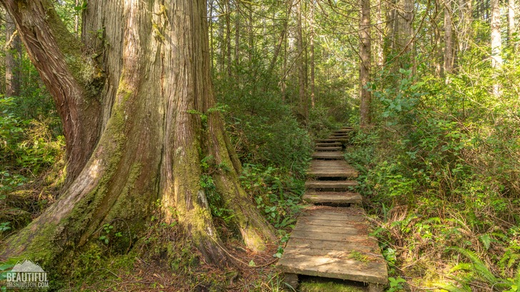
The hike starts near the Ozette Ranger Station. After crossing a lovely Ozette River on an arched wooden bridge the trail will take you to the old growth rainforest of cedar and spruce. Very soon (in approximately 0,25 mile), you will come to the trail junction. Taking the left trail you will get to Sand Point, while hiking the right trail you will reach Cape Alava. The Cape Alava Trail is more often used to get to the beach, and usually the hikers are going back to the Ranger Station by the Sand Point Trail.
Further the boardwalk, meandering through the dense understorey of ferns, salal and other evergreen plants, will take you to the open marsh area, covered by grass, which is called Ahlstrom’s Prairie. In 1902, a Swedish immigrant Lars Ahlstrom built a farm here, breeding sheep and cattle and trying to work the land. None of the buildings of his farm are left right now.
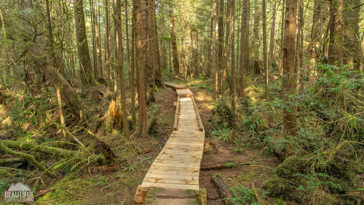
After passing the Ahlstrom’s Prairie the trail enters again the forest, the views of which are somewhat monotonous, but nevertheless lovely. From this point you may feel the first cues of the ocean being close – you will be able to hear the ocean roar and feel the smell of it, brought by the light wind. A little bit further and you will see the first glimpse of the ocean and the trail will go down a small hill to the beach.
Amazing views of the ocean include Tskawahyah Island, located not far away from this point. It’s actually a huge sea stack, the top of which is garnished by trees. If you are hiking the trail during the low tide period, you will be able to walk to the island, which is considered to be the westernmost point of the US (its continental part).
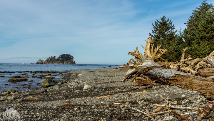
Walking south along the beach you will pass the Wedding Rocks, which comprise the ancient petroglyphs made by Makah people centuries ago. This place has also one of the best ocean views of this coast trail, as well as a couple of campsites which will provide you with solitude and a sandy beach.
This part of the coast is full of wildlife. If you are lucky you will see a harbor seal or a sea lion, resting lazily on one of the rocks, or a beautiful bald eagle, soaring in the sky.
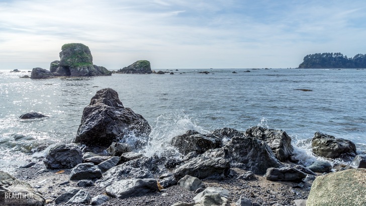
Continue strolling along the gorgeous coastline until you reach Sand Point. This place has beautiful beaches, loved by many tourists. From here you have two options – to continue exploring the Sand Point beaches moving further to the south, or to finish the Ozette Loop by taking the Sand Point boardwalk, leading back to the Ozette Ranger Station.
Mind that for camping at this area you need to receive a permit from the Olympic National Park.
 Ozette Triangle Trail 1
Ozette Triangle Trail 1
Ozette Triangle Trail 1
 Ozette Triangle Trail 2
Ozette Triangle Trail 2
Ozette Triangle Trail 2
 Ozette Triangle Trail 3
Ozette Triangle Trail 3
Ozette Triangle Trail 3
 Ozette Triangle Trail 4
Ozette Triangle Trail 4
Ozette Triangle Trail 4
 Ozette Triangle Trail 5
Ozette Triangle Trail 5
Ozette Triangle Trail 5
 Ozette Triangle Trail 6
Ozette Triangle Trail 6
Ozette Triangle Trail 6
 Ozette Triangle Trail 7
Ozette Triangle Trail 7
Ozette Triangle Trail 7
 Ozette Triangle Trail 8
Ozette Triangle Trail 8
Ozette Triangle Trail 8
 Ozette Triangle Trail 9
Ozette Triangle Trail 9
Ozette Triangle Trail 9
 Ozette Triangle Trail 10
Ozette Triangle Trail 10
Ozette Triangle Trail 10
 Ozette Triangle Trail 11
Ozette Triangle Trail 11
Ozette Triangle Trail 11
 Ozette Triangle Trail 12
Ozette Triangle Trail 12
Ozette Triangle Trail 12
 Ozette Triangle Trail 13
Ozette Triangle Trail 13
Ozette Triangle Trail 13
 Ozette Triangle Trail 14
Ozette Triangle Trail 14
Ozette Triangle Trail 14
 Ozette Triangle Trail 15
Ozette Triangle Trail 15
Ozette Triangle Trail 15
 Ozette Triangle Trail 16
Ozette Triangle Trail 16
Ozette Triangle Trail 16
 Ozette Triangle Trail 17
Ozette Triangle Trail 17
Ozette Triangle Trail 17
 Ozette Triangle Trail 18
Ozette Triangle Trail 18
Ozette Triangle Trail 18
 Ozette Triangle Trail 19
Ozette Triangle Trail 19
Ozette Triangle Trail 19
 Ozette Triangle Trail 20
Ozette Triangle Trail 20
Ozette Triangle Trail 20
 Ozette Triangle Trail 21
Ozette Triangle Trail 21
Ozette Triangle Trail 21
 Ozette Triangle Trail 22
Ozette Triangle Trail 22
Ozette Triangle Trail 22
 Ozette Triangle Trail 23
Ozette Triangle Trail 23
Ozette Triangle Trail 23
 Ozette Triangle Trail 24
Ozette Triangle Trail 24
Ozette Triangle Trail 24
 Ozette Triangle Trail 25
Ozette Triangle Trail 25
Ozette Triangle Trail 25
 Ozette Triangle Trail 26
Ozette Triangle Trail 26
Ozette Triangle Trail 26
 Ozette Triangle Trail 27
Ozette Triangle Trail 27
Ozette Triangle Trail 27
 Ozette Triangle Trail 28
Ozette Triangle Trail 28
Ozette Triangle Trail 28
 Ozette Triangle Trail 29
Ozette Triangle Trail 29
Ozette Triangle Trail 29
 Ozette Triangle Trail 30
Ozette Triangle Trail 30
Ozette Triangle Trail 30
 Ozette Triangle Trail 31
Ozette Triangle Trail 31
Ozette Triangle Trail 31
 Ozette Triangle Trail 32
Ozette Triangle Trail 32
Ozette Triangle Trail 32
 Ozette Triangle Trail 33
Ozette Triangle Trail 33
Ozette Triangle Trail 33
 Ozette Triangle Trail 34
Ozette Triangle Trail 34
Ozette Triangle Trail 34
 Ozette Triangle Trail 35
Ozette Triangle Trail 35
Ozette Triangle Trail 35
 Ozette Triangle Trail 36
Ozette Triangle Trail 36
Ozette Triangle Trail 36
 Ozette Triangle Trail 37
Ozette Triangle Trail 37
Ozette Triangle Trail 37
 Ozette Triangle Trail 38
Ozette Triangle Trail 38
Ozette Triangle Trail 38
 Ozette Triangle Trail 39
Ozette Triangle Trail 39
Ozette Triangle Trail 39
 Ozette Triangle Trail 40
Ozette Triangle Trail 40
Ozette Triangle Trail 40
 Ozette Triangle Trail 41
Ozette Triangle Trail 41
Ozette Triangle Trail 41
 Ozette Triangle Trail 42
Ozette Triangle Trail 42
Ozette Triangle Trail 42
 Ozette Triangle Trail 43
Ozette Triangle Trail 43
Ozette Triangle Trail 43
 Ozette Triangle Trail 44
Ozette Triangle Trail 44
Ozette Triangle Trail 44
 Ozette Triangle Trail 45
Ozette Triangle Trail 45
Ozette Triangle Trail 45
 Ozette Triangle Trail 46
Ozette Triangle Trail 46
Ozette Triangle Trail 46
 Ozette Triangle Trail 47
Ozette Triangle Trail 47
Ozette Triangle Trail 47
 Ozette Triangle Trail 48
Ozette Triangle Trail 48
Ozette Triangle Trail 48
 Ozette Triangle Trail 49
Ozette Triangle Trail 49
Ozette Triangle Trail 49
 Ozette Triangle Trail 50
Ozette Triangle Trail 50
Ozette Triangle Trail 50
 Ozette Triangle Trail 51
Ozette Triangle Trail 51
Ozette Triangle Trail 51
 Ozette Triangle Trail 52
Ozette Triangle Trail 52
Ozette Triangle Trail 52
 Ozette Triangle Trail 53
Ozette Triangle Trail 53
Ozette Triangle Trail 53
 Ozette Triangle Trail 54
Ozette Triangle Trail 54
Ozette Triangle Trail 54
 Ozette Triangle Trail 55
Ozette Triangle Trail 55
Ozette Triangle Trail 55
 Ozette Triangle Trail 56
Ozette Triangle Trail 56
Ozette Triangle Trail 56
 Ozette Triangle Trail 57
Ozette Triangle Trail 57
Ozette Triangle Trail 57
 Ozette Triangle Trail 58
Ozette Triangle Trail 58
Ozette Triangle Trail 58
 Ozette Triangle Trail 59
Ozette Triangle Trail 59
Ozette Triangle Trail 59
 Ozette Triangle Trail 60
Ozette Triangle Trail 60
Ozette Triangle Trail 60
 Ozette Triangle Trail 61
Ozette Triangle Trail 61
Ozette Triangle Trail 61
 Ozette Triangle Trail 62
Ozette Triangle Trail 62
Ozette Triangle Trail 62
 Ozette Triangle Trail 63
Ozette Triangle Trail 63
Ozette Triangle Trail 63
 Ozette Triangle Trail 64
Ozette Triangle Trail 64
Ozette Triangle Trail 64
 Ozette Triangle Trail 65
Ozette Triangle Trail 65
Ozette Triangle Trail 65
 Ozette Triangle Trail 66
Ozette Triangle Trail 66
Ozette Triangle Trail 66
 Ozette Triangle Trail 67
Ozette Triangle Trail 67
Ozette Triangle Trail 67
 Ozette Triangle Trail 68
Ozette Triangle Trail 68
Ozette Triangle Trail 68
 Ozette Triangle Trail 69
Ozette Triangle Trail 69
Ozette Triangle Trail 69
 Ozette Triangle Trail 70
Ozette Triangle Trail 70
Ozette Triangle Trail 70
 Ozette Triangle Trail 71
Ozette Triangle Trail 71
Ozette Triangle Trail 71
 Ozette Triangle Trail 72
Ozette Triangle Trail 72
Ozette Triangle Trail 72
 Ozette Triangle Trail 73
Ozette Triangle Trail 73
Ozette Triangle Trail 73
 Ozette Triangle Trail 74
Ozette Triangle Trail 74
Ozette Triangle Trail 74
 Ozette Triangle Trail 75
Ozette Triangle Trail 75
Ozette Triangle Trail 75
 Ozette Triangle Trail 76
Ozette Triangle Trail 76
Ozette Triangle Trail 76
 Ozette Triangle Trail 77
Ozette Triangle Trail 77
Ozette Triangle Trail 77
 Ozette Triangle Trail 78
Ozette Triangle Trail 78
Ozette Triangle Trail 78
 Ozette Triangle Trail 79
Ozette Triangle Trail 79
Ozette Triangle Trail 79
 Ozette Triangle Trail 80
Ozette Triangle Trail 80
Ozette Triangle Trail 80
 Ozette Triangle Trail 81
Ozette Triangle Trail 81
Ozette Triangle Trail 81
 Ozette Triangle Trail 82
Ozette Triangle Trail 82
Ozette Triangle Trail 82
 Ozette Triangle Trail 83
Ozette Triangle Trail 83
Ozette Triangle Trail 83
 Ozette Triangle Trail 84
Ozette Triangle Trail 84
Ozette Triangle Trail 84
 Ozette Triangle Trail 85
Ozette Triangle Trail 85
Ozette Triangle Trail 85
 Ozette Triangle Trail 86
Ozette Triangle Trail 86
Ozette Triangle Trail 86
 Ozette Triangle Trail 87
Ozette Triangle Trail 87
Ozette Triangle Trail 87
 Ozette Triangle Trail 88
Ozette Triangle Trail 88
Ozette Triangle Trail 88
 Ozette Triangle Trail 89
Ozette Triangle Trail 89
Ozette Triangle Trail 89
 Ozette Triangle Trail 90
Ozette Triangle Trail 90
Ozette Triangle Trail 90
 Ozette Triangle Trail 91
Ozette Triangle Trail 91
Ozette Triangle Trail 91
 Ozette Triangle Trail 92
Ozette Triangle Trail 92
Ozette Triangle Trail 92
 Ozette Triangle Trail 93
Ozette Triangle Trail 93
Ozette Triangle Trail 93
 Ozette Triangle Trail 94
Ozette Triangle Trail 94
Ozette Triangle Trail 94
 Ozette Triangle Trail 95
Ozette Triangle Trail 95
Ozette Triangle Trail 95
 Ozette Triangle Trail 96
Ozette Triangle Trail 96
Ozette Triangle Trail 96
 Ozette Triangle Trail 97
Ozette Triangle Trail 97
Ozette Triangle Trail 97
 Ozette Triangle Trail 98
Ozette Triangle Trail 98
Ozette Triangle Trail 98
 Ozette Triangle Trail 99
Ozette Triangle Trail 99
Ozette Triangle Trail 99
 Ozette Triangle Trail 100
Ozette Triangle Trail 100
Ozette Triangle Trail 100
 Ozette Triangle Trail 101
Ozette Triangle Trail 101
Ozette Triangle Trail 101
 Ozette Triangle Trail 102
Ozette Triangle Trail 102
Ozette Triangle Trail 102
 Ozette Triangle Trail 103
Ozette Triangle Trail 103
Ozette Triangle Trail 103
 Ozette Triangle Trail 104
Ozette Triangle Trail 104
Ozette Triangle Trail 104
 Ozette Triangle Trail 105
Ozette Triangle Trail 105
Ozette Triangle Trail 105
 Ozette Triangle Trail 106
Ozette Triangle Trail 106
Ozette Triangle Trail 106
 Ozette Triangle Trail 107
Ozette Triangle Trail 107
Ozette Triangle Trail 107
 Ozette Triangle Trail 108
Ozette Triangle Trail 108
Ozette Triangle Trail 108
 Ozette Triangle Trail 109
Ozette Triangle Trail 109
Ozette Triangle Trail 109
 Ozette Triangle Trail 110
Ozette Triangle Trail 110
Ozette Triangle Trail 110
 Ozette Triangle Trail 111
Ozette Triangle Trail 111
Ozette Triangle Trail 111
 Ozette Triangle Trail 112
Ozette Triangle Trail 112
Ozette Triangle Trail 112
 Ozette Triangle Trail 113
Ozette Triangle Trail 113
Ozette Triangle Trail 113
 Ozette Triangle Trail 114
Ozette Triangle Trail 114
Ozette Triangle Trail 114
 Ozette Triangle Trail 115
Ozette Triangle Trail 115
Ozette Triangle Trail 115
 Ozette Triangle Trail 116
Ozette Triangle Trail 116
Ozette Triangle Trail 116
 Ozette Triangle Trail 117
Ozette Triangle Trail 117
Ozette Triangle Trail 117
 Ozette Triangle Trail 118
Ozette Triangle Trail 118
Ozette Triangle Trail 118
 Ozette Triangle Trail 119
Ozette Triangle Trail 119
Ozette Triangle Trail 119
 Ozette Triangle Trail 120
Ozette Triangle Trail 120
Ozette Triangle Trail 120
 Ozette Triangle Trail 121
Ozette Triangle Trail 121
Ozette Triangle Trail 121
 Ozette Triangle Trail 122
Ozette Triangle Trail 122
Ozette Triangle Trail 122
 Ozette Triangle Trail 123
Ozette Triangle Trail 123
Ozette Triangle Trail 123
 Ozette Triangle Trail 124
Ozette Triangle Trail 124
Ozette Triangle Trail 124
 Ozette Triangle Trail 125
Ozette Triangle Trail 125
Ozette Triangle Trail 125
 Ozette Triangle Trail 126
Ozette Triangle Trail 126
Ozette Triangle Trail 126
 Ozette Triangle Trail 127
Ozette Triangle Trail 127
Ozette Triangle Trail 127
 Ozette Triangle Trail 128
Ozette Triangle Trail 128
Ozette Triangle Trail 128
 Ozette Triangle Trail 129
Ozette Triangle Trail 129
Ozette Triangle Trail 129
 Ozette Triangle Trail 130
Ozette Triangle Trail 130
Ozette Triangle Trail 130
 Ozette Triangle Trail 131
Ozette Triangle Trail 131
Ozette Triangle Trail 131
 Ozette Triangle Trail 132
Ozette Triangle Trail 132
Ozette Triangle Trail 132
 Ozette Triangle Trail 133
Ozette Triangle Trail 133
Ozette Triangle Trail 133
 Ozette Triangle Trail 134
Ozette Triangle Trail 134
Ozette Triangle Trail 134
 Ozette Triangle Trail 135
Ozette Triangle Trail 135
Ozette Triangle Trail 135
 Ozette Triangle Trail 136
Ozette Triangle Trail 136
Ozette Triangle Trail 136
 Ozette Triangle Trail 137
Ozette Triangle Trail 137
Ozette Triangle Trail 137
 Ozette Triangle Trail 138
Ozette Triangle Trail 138
Ozette Triangle Trail 138
 Ozette Triangle Trail 139
Ozette Triangle Trail 139
Ozette Triangle Trail 139
 Ozette Triangle Trail 140
Ozette Triangle Trail 140
Ozette Triangle Trail 140
You can get there by Hoko-Ozette Road off Highway 112.
In order to get directions click on the map below:
Photo: Roman Khomlyak
Photo Editing: Juliana Voitsikhovska
Information: Svetlana Baranova
Leave your comment